Since it began, the North Runway project has had several departure routes. Only one was used in the original 2005 Environmental Impact Statement, so only that one matches the planning permission.
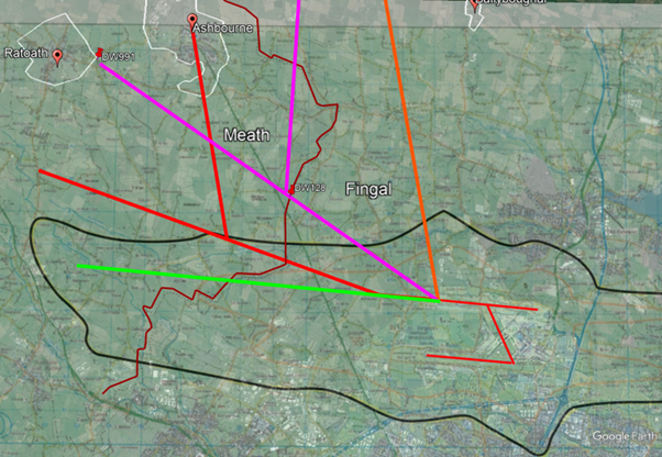
We’ve used Google Earth to display the various routes that AirNav and daa have used for planning, consultation and finally implementation.
- The green line was the route used to create the original Environmental Impact Statement for the original planning application for the north runway project. The black outline is the resulting “outer noise boundary” from that EIS.
- The red lines are the routes used in the 2016 public consultation using a 15 degree turn and subsequent 60 degree turn that would place the majority of the environmental impact in Meath. Every leaflet and every consultation event was in Fingal, and the planning application in which these routes were used was later withdrawn. The red route was never submitted to the IAA for assessment. Story 2 tells how that consultation became daa’s defence.
- When the runway opened, aircraft followed the orange route over Fingal. daa told the Oireachtas Joint Committee on Transport five months later that this “was a surprise to us”. The revised route, from February 2023, moved the impact into Meath.
- The magenta lines show the presently operational routes. Note the orange line was moved just over the border to a newly created waypoint DW128 in Meath. This is the only error daa admits to in the entire process and Kenny Jacobs apologized on PrimeTime for this while insisting that the magenta lines are now “the flight path that was intended”.
So, the only line that put air traffic over Fingal was a mistake and they’re very sorry, while the routes over Meath, which breach daa’s planning permission, are intentional.
When is a flight path not a flight path?
It depends who is talking, and when:
- daa, February 2017, after its public consultation: “Determining flight paths is an important component in the preparation of the EIS”. So a flight path is part of the planning.
- Fingal County Council, warning daa in September 2022: “Aircraft flight paths are not operating in accordance with the permitted flight paths”. So the permission has flight paths in it.
- daa, to the Oireachtas in January 2023: “The actual flight paths, whether they are the deviated or the original, are not a factor of our planning permission.” So it doesn’t.
- AirNav Ireland, May 2023: the departure track “was designed to comply with the 30 degrees minimum divergence requirement”. So it’s a safety requirement.
- On the chart it’s a SID, a Standard Instrument Departure, which the IAA approves for safety.
- The Minister for Transport, September 2026: “flight paths are not a condition of planning at Dublin Airport.”
- Fingal again, September 2026, closing its own enforcement file: flight paths are “not capable of being governed by a planning permission”.
None of them says what it means by a flight path. It can mean three things:
- where one aircraft happens to fly on one day, which air traffic control decides
- the routes every departure is built to follow, the ones the planning permission was assessed on
- the SID, the procedure the IAA approves, which tells the pilots and the aircraft’s computer how to fly the route
The second and third are not two different things. The SID is how the route gets flown. It should put the route the planning permission assessed onto the chart and into the aircraft’s computer, and the aircraft should fly it.
The trick is to treat the SID as a thing of its own: the IAA approves it for safety, so, the argument goes, it has nothing to do with planning. When Fingal warned daa in 2022, daa replied that the permission “did not grant, or purport to grant, planning permission for flight paths”. But the IAA’s approval says a SID is safe to fly. It does not turn a route the planning permission never assessed into a permitted one. Our point is about the routes: the ones the permission was assessed on, and the different ones the SIDs send aircraft along today.
So how far off track are these aircraft?
Let’s look at where they were supposed to leave the “outer noise boundary” when Dublin Airport Authority was granted permission to build the runway. On the left of the map above you’ll find an airplane, 13km from the end of the runway. Aircraft were supposed to follow the green line and begin their turn having already climbed straight ahead at maximum climb efficiency putting them at this point when they exited the noise zone.

On the routes in use today, 13km is in the top right, approaching Ballyboughal. More than half of departures use this early turn to head east and leave the “noise zone” after about 3.5km meaning they are much closer to the ground and the noise zone now looks like the coloured areas. These coloured areas are what daa now calls the “permitted noise zones”, though they are nowhere near the noise zone in its planning permission.
Bottom line: On this track, after 13km flown the aircraft are 12km from where they are supposed to be.
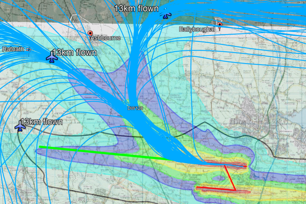
The rest of the traffic heads out over Ratoath. Of course with low altitude turns at the beginning of the track they are at lower altitude because if you’re turning you’re not climbing as well. On this track at low altitude right on top of about 10,000 people instead of over empty fields and solar farms they are “only” 5km from where they are supposed to be.
In summary, daa has not complied with Condition 1 of its planning permission for the North Runway, which requires it to stay within the noise footprint of the original Environmental Impact Statement. Hundreds of flights a day fly over the homes of about 14,000 people instead of over empty fields and solar farms. Calling the current routes “the flight path that was intended” is simply not accurate. The sad thing is that it can be fixed and the damage daa and AirNav are doing to these people is completely unnecessary.
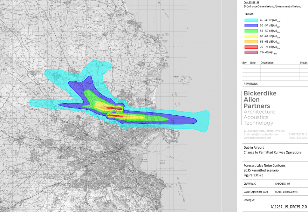
This is the daa noise zone map used in the overlay above. The dB levels in the key are calculated in such a way as to make them as small as possible. When, for example, a 68 dB(A) noise event happens 300 times a day, daa averages it with the normal background noise over 16 hours and calls it 45 to 49 dB(A). This makes sense if you’re willing to accept that having for example an engine running in your back garden every 90 seconds at 65 dB(A) is the same as having the constant sound of something like a stream flowing by all day long at 45 dB(A).
The stories behind this page: how the picture nobody chose became the route, how a box became a Noise Preferential Route, and how a warning letter became the planning board’s mistake.